
Tourist Map
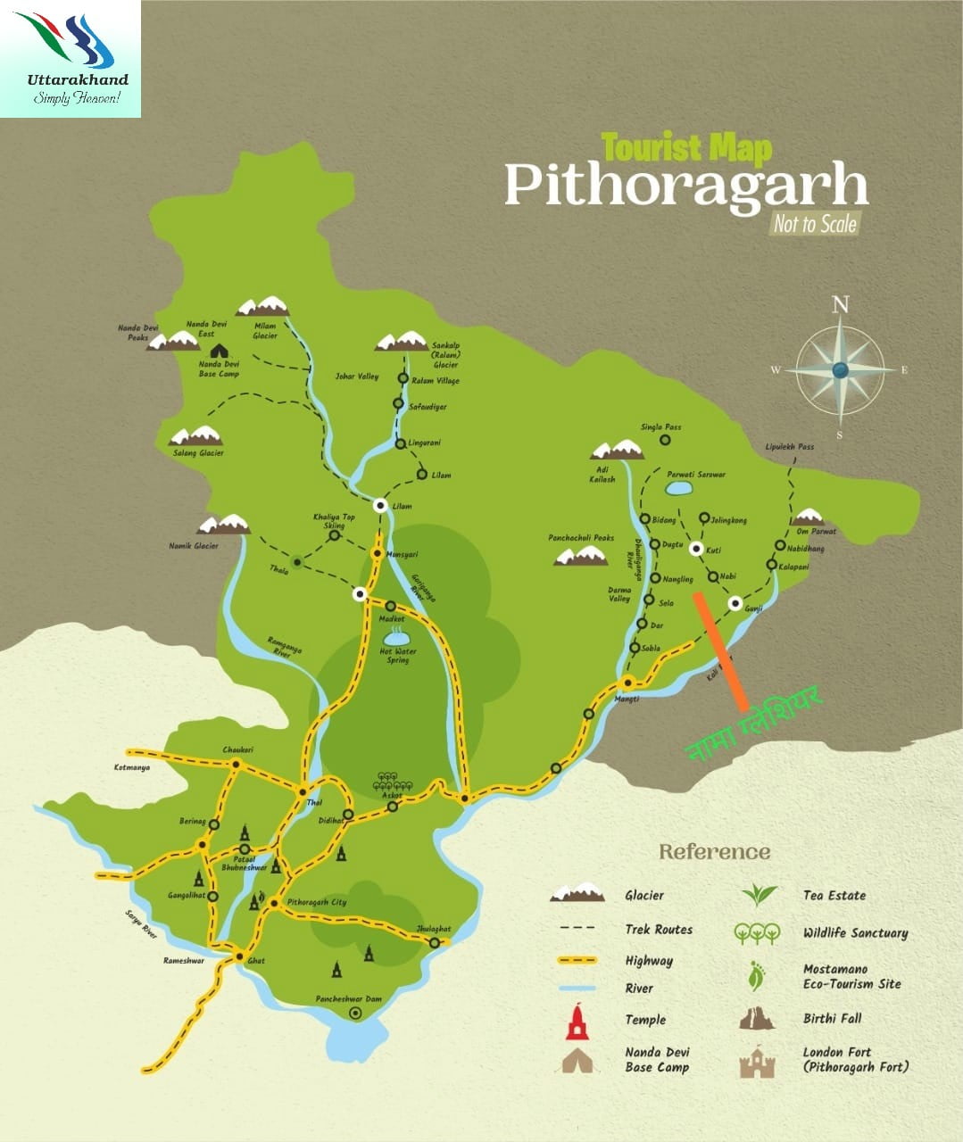
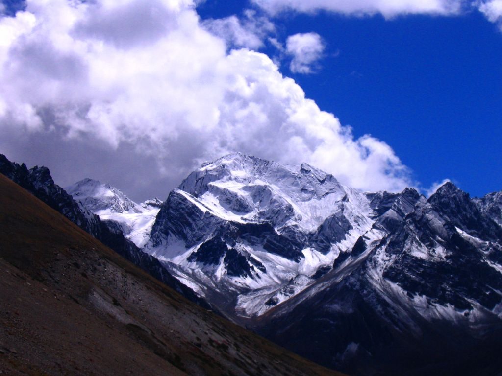
Adi Kailash
Adi Kailash, also known as Shiva Kailash, Chota Kailash, Baba Kailash or Jonglingkong Peak, is a mountain located in the Himalayan mountain range in the Pithoragarh district of Uttarakhand, India.
Parvati Sarovar

Parvati Sarovar is a holy lake located at an elevation of 4,497mts near the peak of Adi Kailash. A shrine of Lord Shiva and Goddess Parvati lies at the shore of the lake. Devotees trekking towards Adi Kailash, pray at the shrine. on Aadi Kailash trekOn the foothills of Aadi Kailash peak of Pithoragarh district of Uttarakhand, India.
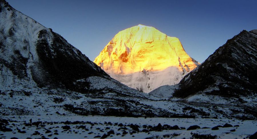
Panchachuli Peaks
The Panchchuli peaks are a group of five snow-capped Himalayan peaks lying at the end of the eastern Kumaon region, near Dugtu Village Darma valley. The peaks have altitudes ranging from 6,334 metres to 6,904 metres. They form the watershed between the Gori and the Darmaganga valleys
Milam Glacier

Milam, one of the most beautiful glaciers of the world is in district Pithoragarh located at the height of 4250 meters above sea level. This glacier has been named after a village Milam located at 3 k.m. away from the Milam Glacier. In ancient time, Milam village was the most populous village of district Pithoragarh but at present its population is almost zero. But its importance is still maintained due to the world’s famous glacier – Milam.River Gori Ganga,a tributary of the river Kali starts from the Milam Glacier.
Askot Sanctuary
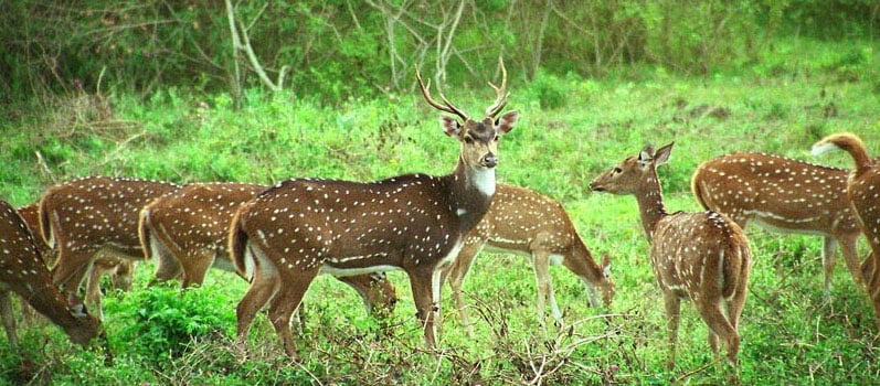
Askot Musk Deer Sanctuary is located 54 km from Pithoragarh near Askot in Uttarakhand state of India. This sanctuary has been set up primarily with the object of conserving the musk deer and its habitat.
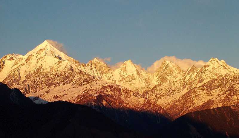
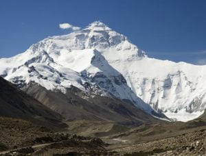
Nanda Devi Peak & Base Camp

Nanda Devi, the second-highest mountain in India, constitutes a pair of massive peaks, namely Nanda Devi East (7,816 m) and Nanda Devi West (7,434 m). The Nanda Devi East affords unmatched views of the two peaks and is as close as one can get to their beauty. The trekkers enjoy serenity beginning from the beautiful settlement of Munsiyari. The trail snakes through dense bamboo forests, verdant alpine meadows, rustic villages, and some of the deepest gorges in the country!
The trek may also reward one with an extremely rare glimpse of the Himalayan Musk Deer, and Snow Leopard. It also introduces trekkers to the culture of the Johari Tribe, which are native to Munsiyari.
Om Parvat
The mighty peak of Om Parvat lies in the Dharchula district of western Nepal and in Pithoragarh District, Uttarakhand, India and is very close to Adinath peak as well. The peak rises to a massive height of 6191 metres from the bosom of the surrounding mountains making this destination is an important landmark en route Kailash Mansarovar Yatra.
One of the most bewitching details of this attraction is the fact that the snow deposition pattern on the surface of the mountain resembles the sacred 'OM', which is an important symbol in Hinduism. Owing to the same, it is considered as an important religious site by Hindus. With a great resemblance to Mount Kailash in Tibet, the view is simply magnificent and enchanting.
Mahakali Temple of Gangolihat

Tehsil and block Gangolihat is at a distance of 77 Km. from Pithoragarh. It is rich in folk culture, music and religious traditions and had been chosen by Sankaracharya for the installation of Mahakali shaktipith. Amidst the cluster of pine trees is situated the shakti temple. The Goddess Kali as represented in her fierce form conquering the demon, is offered sacrifices of lambs and goats. In the direction opposite of the Kali temple about 2 Km. away is situated the Chamunda temple which is believed to be in the centre of an area of wilderness exclusively possessed by spirits and demons conquered by the Goddess in her fierce aspect. The temple has an aura of mystery and weird charm and during the dark hours of night the spirits are believed to have a free sway outside the temple premises.
Patal Bhuvaneshwar

The exposure of Patal Bhuvaneshwar (Lord Shiva in the underground temple complex) is one of this unique way to help mankind. 16 Km. to the north-east of Gangolihat and 20 Km. to the south of Berinag is situated the Patal Bhuvaneshwar cave temple. It is 91 Km. away from the district head quarter and situated at a height of 1350 meters above sea level. The temple place comes under village Bhuvneshwar which is in the tehsil Didihat.The way to the temple is through a narrow tunnel shaped cave, giving a very thrilling experience. The main passage way opens into several small caves which have in them the stone carvings of many traditional Gods & Goddesses and can evoke weird romantic fancies and images in the religiously inclined person. The cave temple of Patal Bhuvaneshwar is traditionally believed to be the abode of thirty three crore deities.
Mostamanu
The Motamanu Temple, Pithoragarh is one of the city’s most visited destinations. This temple is located near Pithoragarh Fort, about 6 km from the main Pithoragarh town. This temple is dedicated to God Mosta, which is considered as the god of this region. Devotees of God Mosta travel far and away while worshiping the deity and receive blessings in the form of prosperity and welfare. In order to celebrate the divine presence of Lord Mouza, a local fair is also organized in the month of August-September, which includes a large number of devotees, travelers, tourists etc. The temple of this hill shows an enchanted view of the entire city and the high valley. The temple complex is large and you can spend some special time here. The pure atmosphere of the temple, body and soul reaches utmost comfort
Pancheshwar Dam

Pancheshwar Dam is a rock-fill dam which is being constructed on the Sarda River(also known as Mahakali in Nepal), which forms the international boundary between India and Nepal.
Jhulaghat

This small town on the Indo-Nepal border is named after a hanging bridge on the Kali River. One can enter Nepal through this bridge. The small market here deals in Nepali goods and other electronic items.
Berinag - The town of Snake Temples

Being garnered with nature’s ethereal beauty, the kaleidoscopic Berinag is nestled in the Pithoragarh district of Uttarakhand. With the word 'Nag' or snake in its name, Berinag is not as precarious as it sounds and is more of a visitor's delight.
Berinag sits at an average elevation of 1,860 meters, about 6,100 feet above sea level and was once popular by the name of Berinag. This place is famous for its ancient snake temples which have been erected in the town itself. Some of the famous attractions located in the proximity of Berinag are Didihat, Patal Bhuvaneshwar and Chaukori.
Thal

A pilgrim spot that is reached through a narrow pathway, the Thal Kedar is nestled at an elevation of 880 meters above sea level. The place is famous for its ancient temple dedicated to Lord Shiva and is mentioned in the ancient text of the Skanda Purana. The location also offers some really amazing views of the valley and is attracts several tourist during the festival of Shivratri every year.
Didihat
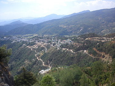
Didihat is a town and a Nagar Palika in Pithoragarh District in the state of Uttarakhand, India. It is one of the eleven administrative subdivisions of Pithoragarh district and also serves as its administrative headquarters.With a population of 6522, Didihat is located at a distance of 520 km (320 mi) from the state capital Dehradun.
Didihat is named after the Kumauni word 'Dand' meaning a small hillock. Didihat falls on the pilgrimage route to Kailash Mansarovar.
Chaukori

Chaukori is a hill station in the Pithoragarh district set among the lofty peaks of the western Himalayan Range in the Kumaon Division of Uttarakhand, India. To its north is Tibet and to its south is Terai. The Mahakali River, running along its eastern boundary, forms the Indo-Nepal international border. This place has become a prominent tourist place and from here a wide and picturesque view of Himalayan range can be viewed. The golden yellow colour of sun rays falling on the Himalayan range in the morning time is really worth seeing. There are cottages available here where one can stay and enjoy the serene surroundings. Tourists coming to this place generally also visit the nearby tourist places like Patal Bhuvaneshwar, Kausani, Bageshwar and Almora.
Namik Glacier
“Namik”, which means the presence of saline water springs, defines the glacier located at 3600 metres, in the Pithoragarh District of Uttarakhand. This glacier is prominently known for the Trek leading upto the glacier, which promises adventure enthusiasts a thrilling and mesmerising journey.
In the lap of nature, surrounded by the splendour of peaks like Nanda Devi, Trishul, Nanda Kot and waterfalls along with sulphur springs, this trek has a lot to offer to tourists. The trek, which falls on an ancient Indo-Tibetan trade route, also promises a dose of local culture as the trail passes through pristine villages with their own independent and strong local cultures. These villages are rich in heritage; two villages, Gogina and Namik, deserve special mention. Did you know, Namik Glacier is also the source for Ramgana River, and thus the trail broadly follows the River through a unique combination of forests and meadows, with the eternal Himalayas in constant view.
The base for the trek starts at Chaukori-Munsiyari (2290 metres) and follows a trail through Senar Gad Meadows, Dhaldauk, Sudam Khan, Hiramani Glacier and finally ends at Namik Glacier. Due to the challenging nature of the trek, which goes on for 59 Kms (one way), people are well-advised to set aside 10 days (minimum) to savour the beauty of the journey.
May, June, September and October are the best months to go on this trek.
Khaliya Top

Khaliya top is the best location for adventure lover, Khaliya top of Munsiyari town, a Tehsil and Sub Division in the Pithoragarh District in the hill-state of Uttarakhand is situated almost 11500ft above the sea level hidden amidst the alpine trees with scenic views of Panchachuli peaks along the whole trek
Johar Valley
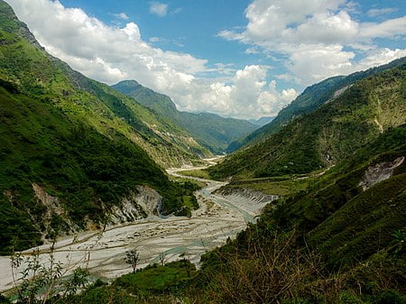
Johar Valley (also known as Milam Valley or Gori Ganga Valley) is a valley located in Uttarakhand, India, along the Gori Ganga river. The valley used to be a major trade route with Tibet. The best known villages in the valley are Martoli and Milam.
Madkot

Madkot is a scenic village in Pithoragarh district. It is about 21 km away from popular hill station Munsiyari, through typical hilly roads. Madkot is popular among tourists for its:
- Hot water spring
- Vegetation
- Snowfall
- Natural beauty
- And rich culture of local Bhotiya tribes.
It sits at an elevation of about 2,200 m (7,200 ft) above sea level. After visiting Khaliya top, Madkote is the place which is worth visiting.
Darma Trek - Valley of Remote Villages

A lesser-known valley, the picturesque Darma Valley (or Darma Ganga Valley) is nestled between two other valleys, namely the Kuthi Yangti Valley in the east and Lassar Yangti Valley in the west.
Perched at an altitude of 3470 mts, Darma Valley is formed by the Darma River (also known as Darma Ganga River) and offers stunning views of the Panchachuli peaks.
Darma Valley trek and Panchachuli Base Camp Trek follows the same route, the only difference is that trekkers are going to explore the vicinity of Darma Valley more deeply.
Om Parvat

Snow treks are some of the most fascinating things to do in the Himalayas. And if you add to that some mystery and a certain aspect of mythology, the enthusiasm to complete the trek reaches new heights. That is what the Om Parvat trek is about. Mythologically speaking, this place is considered to be one of the oldest abode of Lord Shiva. Related to the legend of Ravana, the peak is considered sacred by many, and the Om Parvat trek leads to an astounding view of the giant and the impression of 'OM' made on the facade by the snow.
Located in the snowy Himalayas of the Kumaon region in Uttarakhand, the Om Parvat trek starts and ends in Kathgodam, passing through many small towns and villages to finally arrive at the magnificent view of the Om Parvat. Rising to an altitude of 14816 ft, this peak is also referred to by several other names such as Adi Kailash, Chota Kailash, Baba Kailash, and Jonglingkong. A virgin peak largely because of its religious significance, the most astounding trait of this peak is the miraculous impression of “OM” naturally formed with the deposition of snow against the black background of the mountain.
Kuti Village
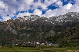
Dharchula town is encircled by many small villages. Kuti village is one of them. Kuti village is a culturally vibrant village with over 115 traditional houses. It is one among the 73 villages of Dharchula Block of Pithoragarh district. This place is a major halt for people proceeding to the Adi Kailash trek.